|
A
A
A
|
Home
|
Login
|
Your Cart
|
Checkout
|
Contact
Search Products
Products
New Products
Tourist Products
Map Bundles
National Park, Walk & Recreation Maps
1:50 000 Topographic Maps
1:250 000 Topographic Maps
National Park, Walk & Recreation Digital Maps
1:25 000 Digital Products
1:50 000 Digital Products
1:100 000 Digital Products
1:250 000 Digital Products
Administration and Tenure Maps
1:25 000 Topographic/Cadastral Maps
1:100 000 Topographic Maps
Wall Maps and Posters
Free Map Products
Historical Charts
Historical Maps
TASMAP on Facebook
All Products
Home
>
1:25 000 Topographic/Cadastral Maps
The 1:25,000 Topographic/Cadastral mapping series has been archived following the introduction of the 1:50,000 Topographic mapping series in 2015.
The 1:25 000 Topographic/Cadastral Map Series portray highly detailed topographic information such as roads, rivers, lakes, vegetation and relief. Also shown is cadastral data, Local Government Area boundaries and locality boundaries which makes these maps invaluable for property related searching. The Land Parcel Identifiers (LPI) give a quick visual reference to individual properties over 2 hectares in size and link to the Property, Valuation and Title databases via the LIST website.
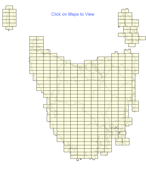
The Series covers the entire State with 415 maps. Each map covers a 10 x 20 kilometre area with a 1 kilometre grid based on the Universal Transverse Mercator projection (UTM). At this scale, 1 millimetre on the map represents 25 metres on the ground. Since 2003 these maps have been produced on the Map Grid of Australia (MGA94) which utilises the Geocentric Datum of Australia 1994 (GDA94). GDA94 maps have an overlapping bleed edge on the northern and eastern sides. This extension fills the gap between the older Australian Map Grid 1966 (AMG66) / Australian Geodetic Datum 1966 (AGD66) maps and the new maps on the GDA94 datum.
413 items in
1:25 000 Topographic/Cadastral Maps
1 |
2
|
3
|
4
|
5
|
6
|
7
|
8
|
9
Code
Name
Price
Buy
4029
Abel 1:25000 Topographic/Cadastral Map
AUD9.95
4436POD
Ada 1:25000 Topographic/Cadastral Map
PRINT ON DEMAND ONLY
AUD55.00
4036
Achilles 1:25000 Topographic/Cadastral Map
AUD9.95
4426
Adamsfield 1:25000 Topographic/Cadastral Map
AUD9.95
3251
Adamson 1:25000 Topographic/Cadastral Map
AUD9.95
5220
Adventure Bay 1:25000 Topographic/Cadastral Map
AUD9.95
3237
Ahrberg 1:25000 Topographic/Cadastral Map
AUD9.95
3530-3531
Albina-Table Head 1:25000 Topographic/Cadastral Map
AUD9.95
4230
Algonkian 1:25000 Topographic/Cadastral Map
AUD9.95
5853
Anderson 1:25000 Topographic/Cadastral Map
AUD9.95
4424POD
Anne 1:25000 Topographic/Cadastral Map
PRINT ON DEMAND ONLY
AUD55.00
6045
Ansons Bay 1:25000 Topographic/Cadastral Map
AUD9.95
5835
Apslawn 1:25000 Topographic/Cadastral Map
AUD9.95
4232
Arrowsmith 1:25000 Topographic/Cadastral Map
AUD9.95
5859
Arthurs 1:25000 Topographic/Cadastral Map
AUD9.95
4835
Arthurs Lake 1:25000 Topographic/Cadastral Map
AUD9.95
5653
Badger 1:25000 Topographic/Cadastral Map
AUD9.95
5228
Bains 1:25000 Topographic/Cadastral Map
AUD9.95
3242
Balfour 1:25000 Topographic/Cadastral Map
AUD9.95
3642
Baretop 1:25000 Topographic/Cadastral Map
AUD9.95
5222
Barnes Bay 1:25000 Topographic/Cadastral Map
AUD9.95
5852
Barretts 1:25000 Topographic/Cadastral Map
AUD9.95
4843
Beaconsfield 1:25000 Topographic/Cadastral Map
AUD9.95
4844
Bell Bay 1:25000 Topographic/Cadastral Map
AUD9.95
5441
Ben Nevis 1:25000 Topographic/Cadastral Map
AUD9.95
3442
Bertha 1:25000 Topographic/Cadastral Map
AUD9.95
3443
Beryl 1:25000 Topographic/Cadastral Map
AUD9.95
6036-6037
Bicheno-Seymour 1:25000 Topographic/Cadastral Map
AUD9.95
6043
Binalong 1:25000 Topographic/Cadastral Map
AUD9.95
3629
Birchs 1:25000 Topographic/Cadastral Map
AUD9.95
3050
Bird 1:25000 Topographic/Cadastral Map
AUD9.95
4619
Bisdee 1:25000 Topographic/Cadastral Map
AUD9.95
5223
Blackmans Bay 1:25000 Topographic/Cadastral Map
AUD9.95
5240
Blessington 1:25000 Topographic/Cadastral Map
AUD9.95
3838
Block 1:25000 Topographic/Cadastral Map
AUD9.95
5843
Blue Tier 1:25000 Topographic/Cadastral Map
AUD9.95
3045POD
Bluff 1:25000 Topographic/Cadastral Map
PRINT ON DEMAND ONLY
AUD55.00
4620POD
Bobs 1:25000 Topographic/Cadastral Map
PRINT ON DEMAND ONLY
AUD55.00
5829
Boltons 1:25000 Topographic/Cadastral Map
AUD9.95
4238
Borradaile 1:25000 Topographic/Cadastral Map
AUD9.95
5030
Bothwell 1:25000 Topographic/Cadastral Map
AUD9.95
4425
Bowes 1:25000 Topographic/Cadastral Map
AUD9.95
5245
Bowood 1:25000 Topographic/Cadastral Map
AUD9.95
4836
Bradys Lookout 1:25000 Topographic/Cadastral Map
AUD9.95
4020
Breaksea 1:25000 Topographic/Cadastral Map
AUD9.95
4637
Breona 1:25000 Topographic/Cadastral Map
AUD9.95
4841
Bridgenorth 1:25000 Topographic/Cadastral Map
AUD9.95
5246
Bridport 1:25000 Topographic/Cadastral Map
AUD9.95
5841
Brilliant 1:25000 Topographic/Cadastral Map
AUD9.95
5027
Broadmarsh 1:25000 Topographic/Cadastral Map
AUD9.95
1 |
2
|
3
|
4
|
5
|
6
|
7
|
8
|
9